Office Closed On July 4th

About Backcountry Journeys
Why Choose Backcountry Journeys
If you're considering a photography tour, hear why Backcountry Journeys delivers the best experience in the industry.Frequently Asked Questions
If you're new to photography tours, or new to BCJ, you can find our common travel questions here.Fitness Levels
Our trips vary on physical intensity, and by reviewing our fitness levels, you can find out which trips may be more challenging, or aligned more closely with your comfort level.Meet The Crew
We've built an amazing team of experienced guides, and dedicated office staff that elevate your travel experience. Get to know their backgrounds, and hear their stories.Travel Desk
You can review our various payment, and travel policies here, along with resources regarding international travel.Gift Certificates
Give the gift of photo adventure! We offer gift certificates that can be applied to any of our upcoming tours.Loyalty Program
We reward our frequent photo adventurers with exclusive discounts on amazing photography tours.Contact Us
If you need to get in touch with our office staff, or have additional business inquiries, you can find our information here.Stay Up To Date On All Things
Backcountry Journeys
Backcountry Journeys
Our Photography Community
Our Webinars
Our regularly hosted webinars provide photography instruction from our own guides on a wide range of topics.Our Education Portal
Explore our library of articles that cover everything from common questions, to in-depth guides on how to achieve that perfect shot.Community Testimonials
We're proud to foster an amazing group of photo travelers, and here you can find their stories from their past adventures.Resources For Photographers
About Our Company
Resources For Photographers
About Our Company
Trip Report: Yosemite Fall Colors – Oct/Nov 2019
Published December 9, 2019
Where does one begin in an attempt to describe Yosemite National Park? It is a place rife with history, intense biodiversity, and perhaps some of the most dramatic landscapes anywhere on earth.
It seems that over the past century and a half, people from around the world keep rediscovering this incredible landscape, for its granite domes and sheer granite walls, its groves of ancient sequoias, and for its pristine high country wilderness.
And as a photographer and guide navigating the oldest federally protected wilderness in the world, new opportunities abound everywhere, if you know where to look. And, for us at Backcountry Journeys, with dozens of years of combined experience exploring Yosemite, it is a wonderful challenge to keep exploring and developing new vantage points from which to see and photograph one of the most iconic landscapes in the world.
Though Yosemite has one of the highest rates of visitor attendance of any of the U.S. National Parks (fifth amongst U.S. National Parks with 2018 attendance at 4 million visitors), it is interesting that during autumn, when the leaves turn to gold, that attendance is so low. But, this makes it absolutely one of the best times to visit, with a double advantage of no crowds and a technicolor landscape to frame in your lens.
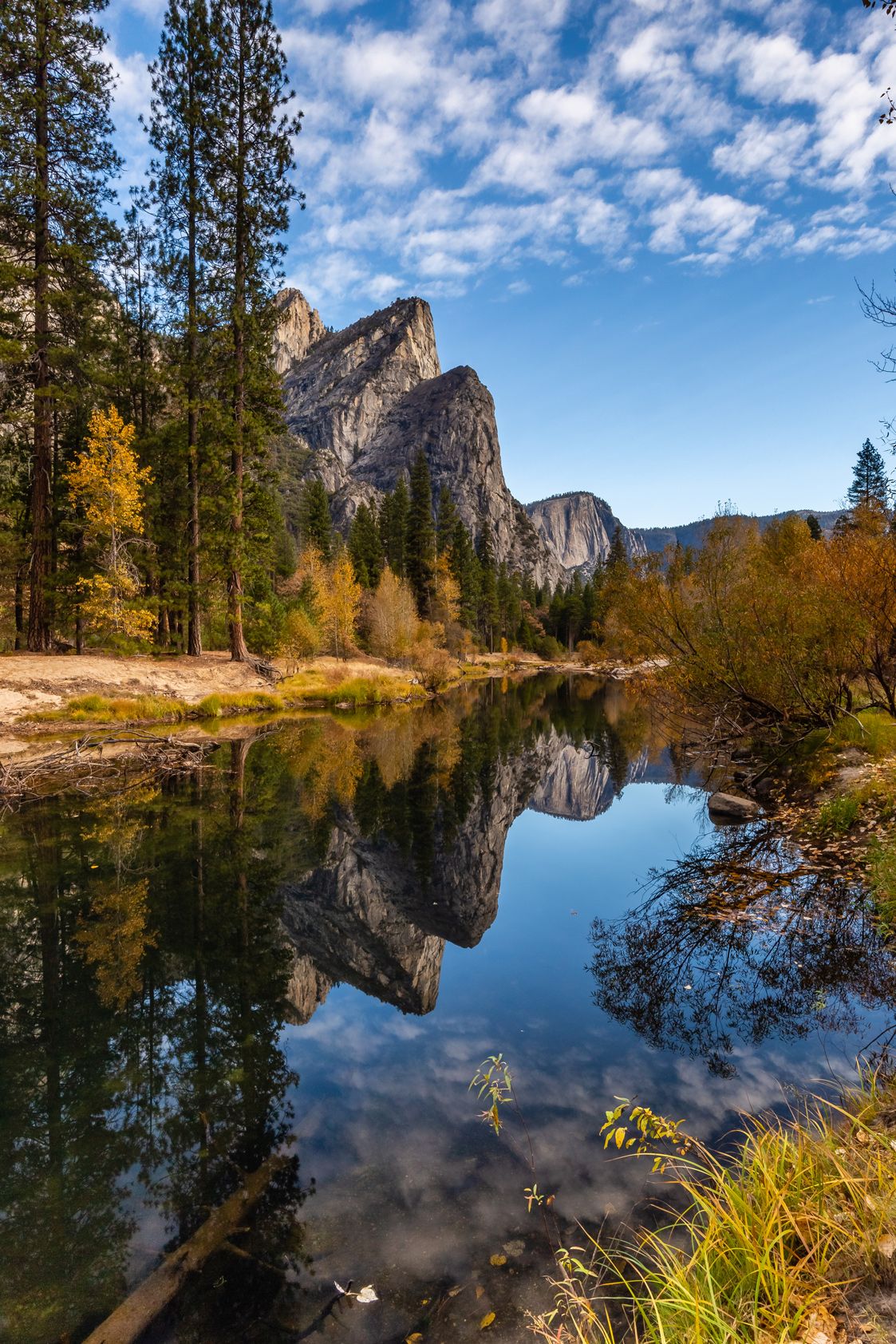
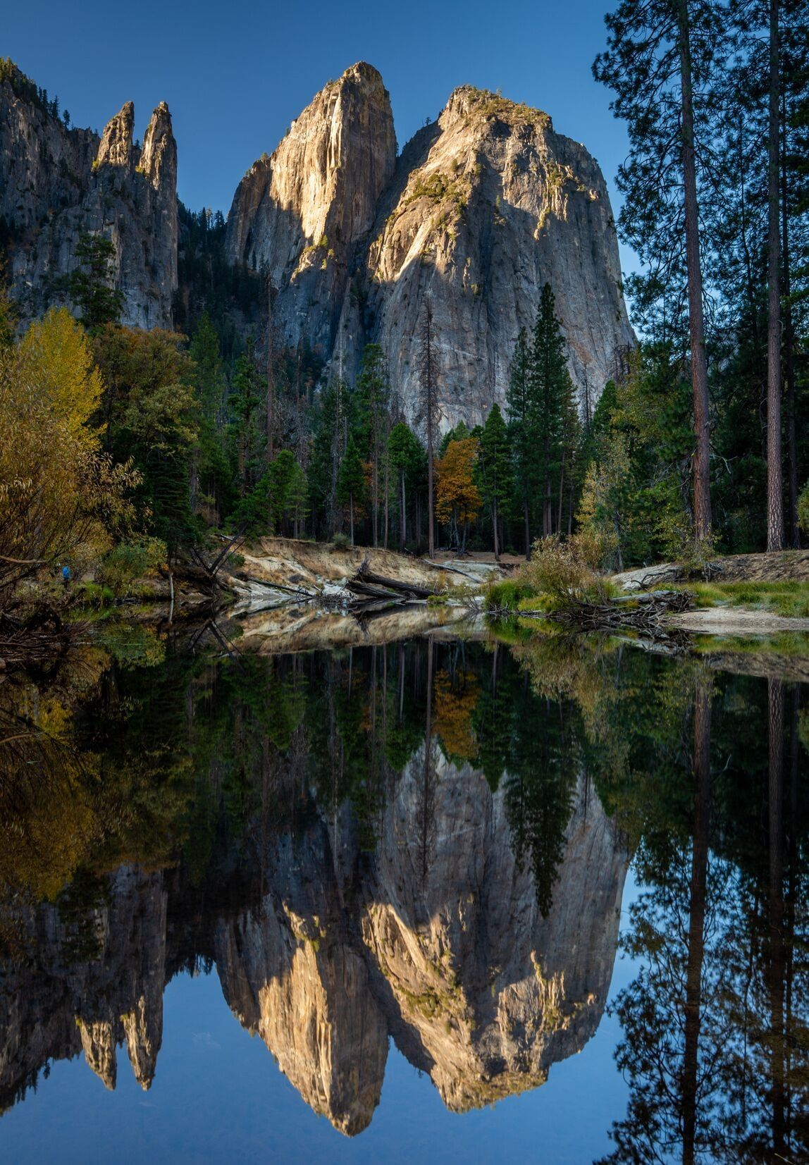
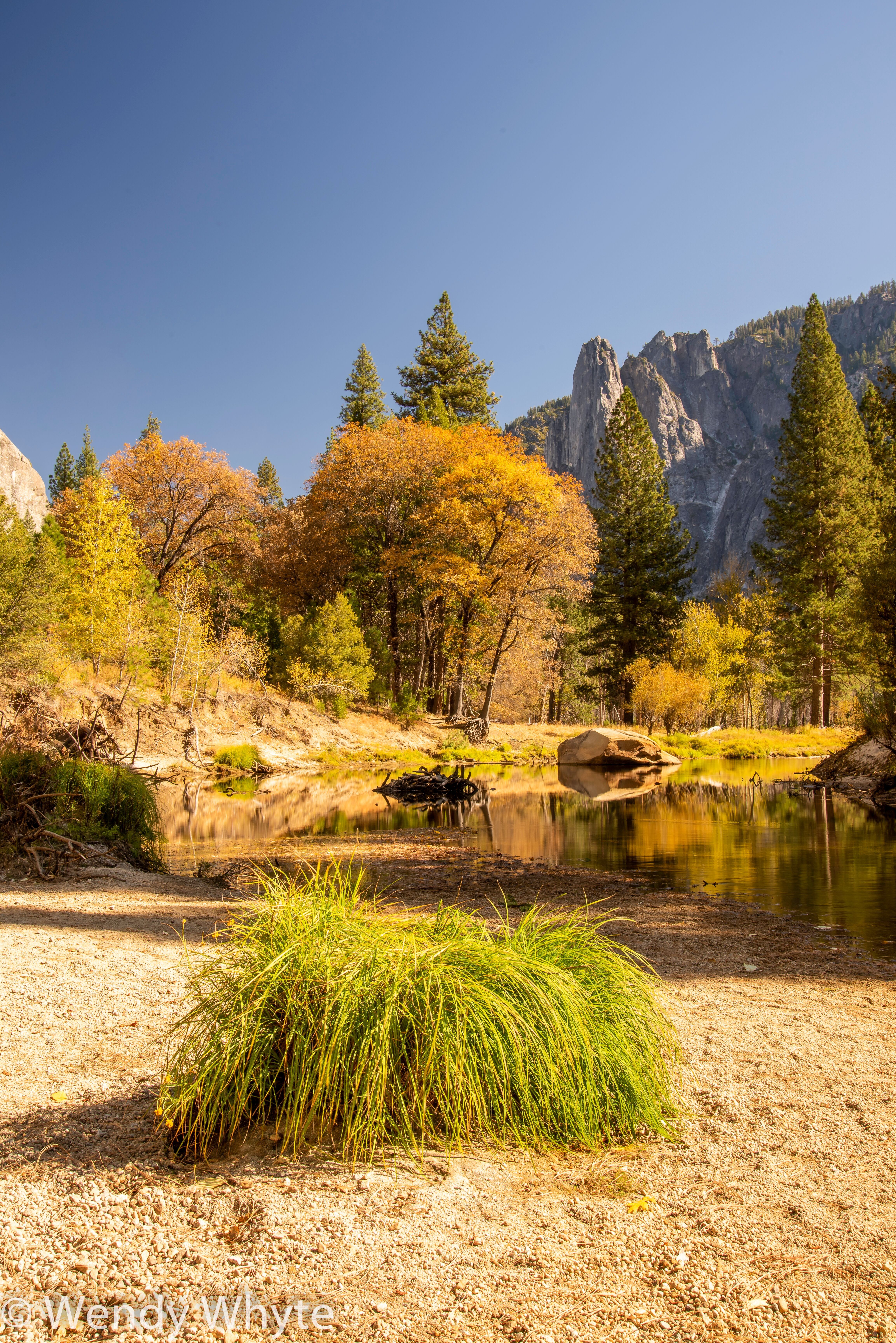
This year, we ran two groups through Yosemite, as is the norm, one being our standard trip itinerary, and the other being our hiker style tour. With the standard group, our destinations are of course limited to where there is vehicle accessibility. But, that is not to say that there is a lack of incredible photographic opportunities for both groups. And one of the primary reasons for this is Yosemite Valley. The 7.5 miles long Yosemite Valley makes up just 1% of the park’s total area but is the focal point of most visitors’ journeys. Ringed with such famous granite features as El Capitan, Cathedral Rock, and Half Dome, the valley is a smorgasbord of photographic subject matter. The valley is drained by the Merced River (French for River of Mercy), which is fed by an incredible collection of waterfalls. One amazing aspect of the valley that makes it so special photographically is an endless collection of opportunities for featuring the park’s dramatic peaks reflected in the calm waters of the Merced. And, we at BCJ have developed a long list of vantage points to make use of this unique feature of Yosemite Valley.
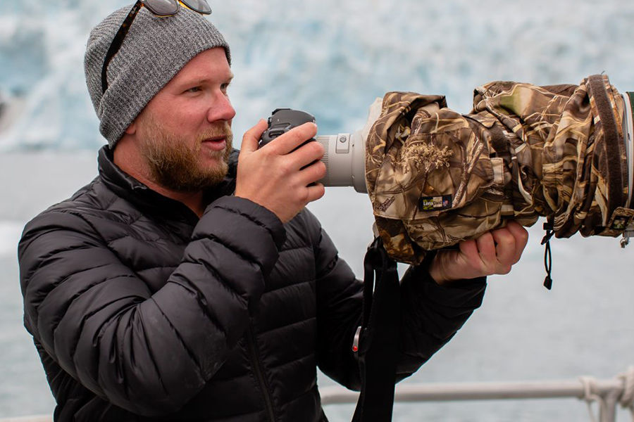
Ben Blankenship
Ben Blankenship
The Merced River first descends into Yosemite Valley by making two enormous drops over Nevada Falls and then Vernal Falls. From there, it rushes its way through rockfalls and glacial erratics before eventually slowing as it smooths out along the near-level ground of the valley floor. Here, its waters widen out and slow to create a mirror-like surface as it curves and rolls along the 7.5-mile length of Yosemite Valley, kissing the bases of the valley’s famous granite monoliths as it goes. The loop road that rings the valley moves along the banks of the Merced, with dozens of pullouts along the way providing access to some of the better known and more secret vantage points. Many of the vantage points have established names, such as Valley View, El Cap Meadow, and Sentinel Bridge, which are published in all of the photo books on Yosemite. Other lesser-known vantage points bear the names gifted to them by photographers and artists over the years. Even though many of these names are not part of the park’s official record, they are well known amongst those that obsess over the majesty of Yosemite and its famous valley, vantage points such as Tahiti Beach, The Tree, and Cathedral’s Pond. And beyond these, there are dozens more vantage points that have yet to have been bestowed a consensus designation. And for these, we as guides and photographers each have our own set of names that we use to navigate and plan excursions, names such as Meisenheimer’s Scramble (Yes, I named this one after our own Matt Meisenheimer), Afternoon Sentinel, and Ben’s Cathedral Crouch.
As you might’ve deduced already, these names are often associated with either the guide who developed the shot, or perhaps the timing or vantage point associated with the location.
Either way, the point is that we possess a long list of epic vantage points from which to shoot the valley that rarely requires walking more than a half-mile from the car, and often times much less. For this reason, for both the standard and hiker groups, we focus our sunrise efforts there in the valley, for its ease of access, and because it allows us the opportunity to hop from location to location as the morning light in the valley progresses, maximizing our time behind the camera and minimizing travel time. This, to me, represents one of the best reasons for utilizing a guide to photograph Yosemite. Surely, with enough time and research, one could generate a solid list of photographic vantage points from which to shoot. But, with the advantage of a guide, photographers can avoid the hours of research and also be taken to locations as the perfect light develops. And, as a feature of the high valley walls, the morning light moves from cliff to cliff in a sequence that only experience will allow one to decipher completely. It is a delicate dance at times, chasing the morning light as it skirts along the jagged granite cliffs and domes, but it is part of what makes photography in Yosemite Valley such a unique experience.
Wendy Whyte
It has been well-publicized over the past several years that southern California has been dealing with shortages on rain, and therefore an increase in wildfires. And though we at BCJ would never want to make light of or minimize the struggle that Californians have been going through in terms of loss of property and life, it is through the lens of photographers exploring their beautiful state that we observe this developing climate emergency. And it is one of the most common questions that we receive as guides working in Southern California, “how are the fires affecting the photography?”
This is obviously a very fair question for anyone planning a trip to Yosemite, and so let’s get it out of the way now. Firstly, none of the fires burning this past fall were within 100 miles of Yosemite National Park. But, fires create haze and atmosphere that can travel hundreds of miles on wind currents. And, this was most definitely visible within the park, specifically during the late afternoon. Though the haze did not affect most of our photographs, one vantage point where it did have a detrimental effect was at Tunnel View, one of the most famous photo locations in the park. But, there is a trade-off to a hazy view. As the sun descends to the horizon, the smoky atmosphere lights up with oranges, reds, and pinks. Some of the most beautiful sunsets occur when there is a large amount of particulate matter in the atmosphere, whether it be from fire, dust, or precipitation. This is why African savannah sunset shots are often so epic; it is because of the enormous amount of red dust being blown up into the air. And the same was true for nearly every sunset we saw during our two weeks in Yosemite. The smoke from the distant fires lit with kaleidoscopic colors that lingered there in the sky long after the sun had slipped below the horizon.
We did experience a new aspect of California’s fire season this year though, which was power outages. The story goes like this; apparently last year, intense Santa Ana winds blew down power lines which then ignited the tinder-dry brush, thus creating devastating wildfires, and enormous losses of property and life. As a result of this, Pacific Gas and Electric (PG&E) was sued substantially for gross negligence. And so, this year, when the annual Santa Ana winds came whipping in from the Pacific and into a very dry California countryside, PG&E cut the power to prevent a repeat from last year. The result was hundreds of thousands of Californians without power for days on end, sometimes weeks in some areas. And, not so luckily for our clients on the Standard Trip, Yosemite Valley was on PG&E’s list of regions to go dark. Our blackout lasted just short of three days (two nights). Even though the valley was windless, the areas through which Yosemite’s power lines had to travel to reach us were very vulnerable. And though we had to navigate by head torch in some frigid hotel rooms by night, everyone handled in stride. If nothing else, it certainly added to the sense of adventure of the whole trip. And so, I have to express a special thanks to Wendy and David for being so tough.
Despite the issues created by California’s fire season, our standard group accomplished some incredible photographs from within the valley, as well as by venturing out to Olmsted Point, Glacier Point, and Tunnel View.
There is certainly never a shortage of irony when it comes to navigating the wilds in search of epic photography. And, as I could’ve guessed would happen, as soon as the power was back on, the weather warmed significantly. And shortly after the arrival of change in temperature came our hiker group.
Each day of the hiker version of our Yosemite in Fall trip begins much the same way as the standard trip, with a medley of beautiful vantage points throughout Yosemite Valley. But, by midday, the difference becomes stark. Each of our full days in Yosemite National Park, we embark on ambitious and beautifully rewarding treks into the lesser-seen areas of the park.
Hiking in Yosemite is at times challenging, with some fairly significant gains in elevation, but the payoffs make the climbs well worth the effort. There are dozens of day hiking trails to explore in the park, and we at BCJ have narrowed that list down to some absolute winners that get our clients high up above the valley and into some remote and pristine wilderness.

Ben Blankenship
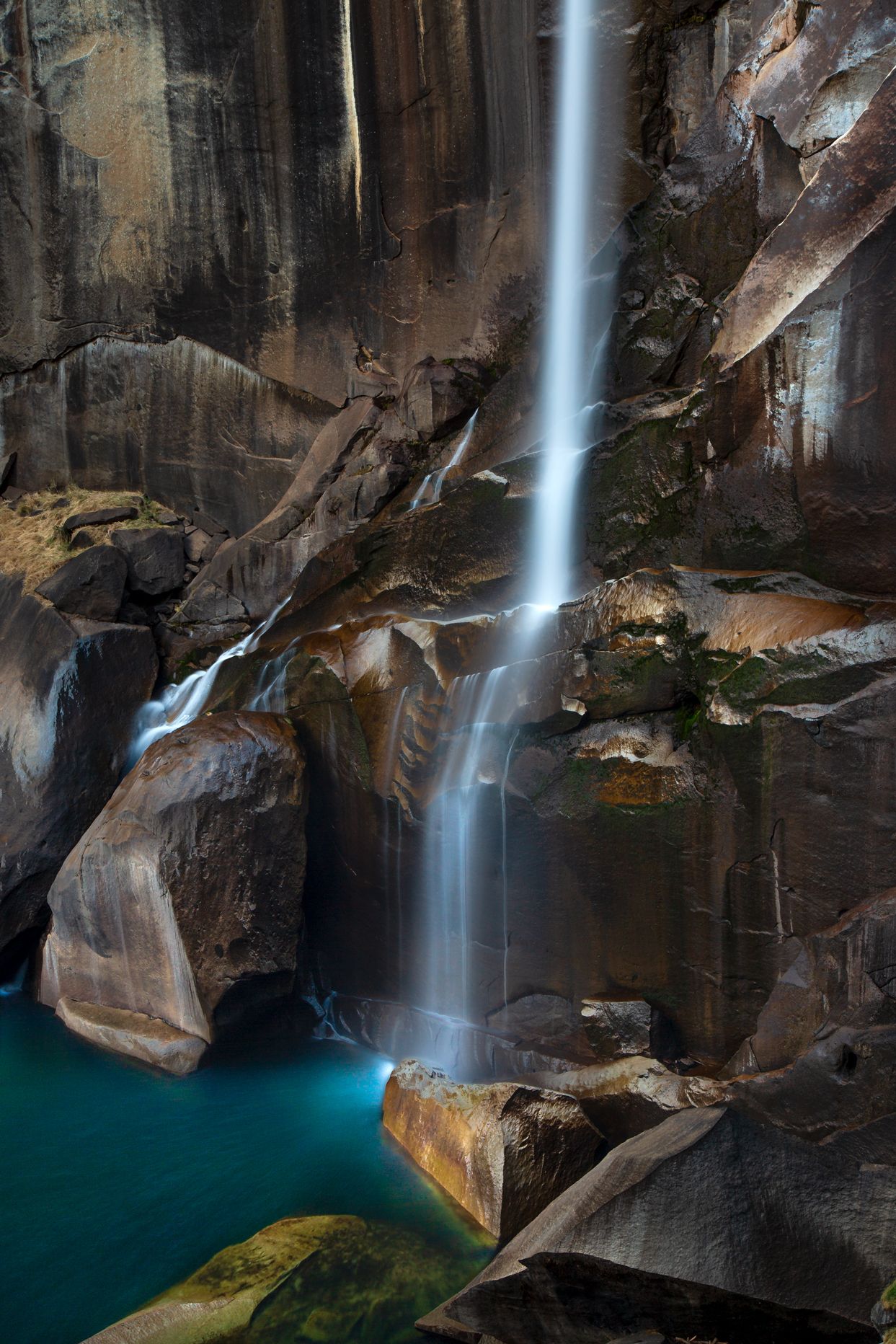
Our first hike of the trip was the famous Mist Trail. This hike is one of the most popular in the park, though it is perhaps one of the most challenging in terms of elevation gain over a short distance. From the valley floor, hikers ascend over 1000 feet over two miles to the top of Vernal Falls. Vernal Falls marks the point where the Merced River begins its final descent to the Yosemite Valley floor. And, its flow fluctuates greatly from season to season. In Spring, when the flow is at its peak, the falls spans a twenty-foot wide gap with a roaring flow. But, by fall, the girth of the falls is reduced to just a few feet. But, this can be advantageous, because the mist from the falls, from which the trail gains its name, is greatly reduced, making the ascent up the stone stairs carved into the mountainside much easier.
After a steep climb up the stairs, hikers reach the final ascent to the top of Vernal, which is a sort of stone ramp carved into a sheer granite wall that provides passage over the last 50 yards or so. But don’t worry; there is a railing. At the top of Vernal, there are amazing views down through the tight gorge created by the flowing Merced. And just beyond the falls is the Emerald Pool, an enormous stone bowl growing with green moss and filled with crystal clear water.
We always break here for thirty minutes or so to have a snack, shoot some photos, and rest up for the next level of ascent up to Nevada Falls. After departing Vernal Falls, the number of other hikers on the trail dissipates significantly as the trail meanders into some beautiful backcountry. It crosses bridges and skirts along the edge of Liberty Cap, a beautiful granite dome. The trail then winds through Douglas fir and ponderosa pine forest before emerging from the woods on a switchback cut from white granite.
Ben Blankenship
This year, at this point in the hike, we had climbed about 1500 feet since departing from the valley floor, and most everyone was feeling quite tired. So, instead of ascending all the way to the top of Nevada Falls, we stopped here. But, the view of Nevada Falls from here is quite spectacular, as it drops over 500 feet in total from a ledge just overhead before splashing down hundreds of feet below our perch on the trail. There are great photos to be had here of the falls and the surrounding scenery in the late afternoon sun, so we did fine to cut the hike a bit short. From here we turned around and headed back down the way we had come, making sure to descend the steep stone stairs before dark.
The following day, after an epic morning of shooting photos of El Capitan, Cathedral Rock, and Three Brothers in the early morning light, we would be heading up to the northeast corner of the park for Cathedral Lake.
The north side of Yosemite National Park consists of some incredible high country wilderness. Unlike the southern parts of the park, including Yosemite Valley, the north side is largely undeveloped backcountry. Even in summer, when crowds fill the valley, one can still find solace amongst giant groves of Douglas fir and alpine lakes in Yosemite’s north country.
From the valley floor, we took the Tioga Road northeast, climbing from an elevation of 4,000 feet at the valley floor to over 9,000 feet at the Tioga Pass. The drive was over an hour to our trailhead, but along the way, we were able to observe glistening lakes, white granite domes, and high Sierra peaks along the road.
The trail to Cathedral Lake is part of the John Muir Trail, a 213-mile long distance trail through California’s Sierra Mountain Range that traverses through Yosemite, King’s Canyon and Sequoia National Parks. But, we would only be hiking a 3.5-mile portion of this famous trail.
From our trailhead in Tuolumne Meadow, the trail begins to ascend immediately. Beginning at an elevation of around 9,000 feet, the trail crescendos at around 10,000 feet after about 3 miles of hiking. And though the elevation gain is not so intense as the Mist Trail, hiking at an elevation of 9,000 to 10,000 feet poses its own cardio challenges, which makes the payoff at the end all that much more rewarding.
The trail’s first mile is a mostly uphill climb before flattening out for another mile or so. It then tilts upward again for one more mile. This three mile stretch of trail is absolutely stunning as it meanders through ancient groves of Douglas fir, white pine, and Jeffrey pine. From time to time, the trail moves through high country meadows, revealing the awesome array of granite peaks surrounding us.
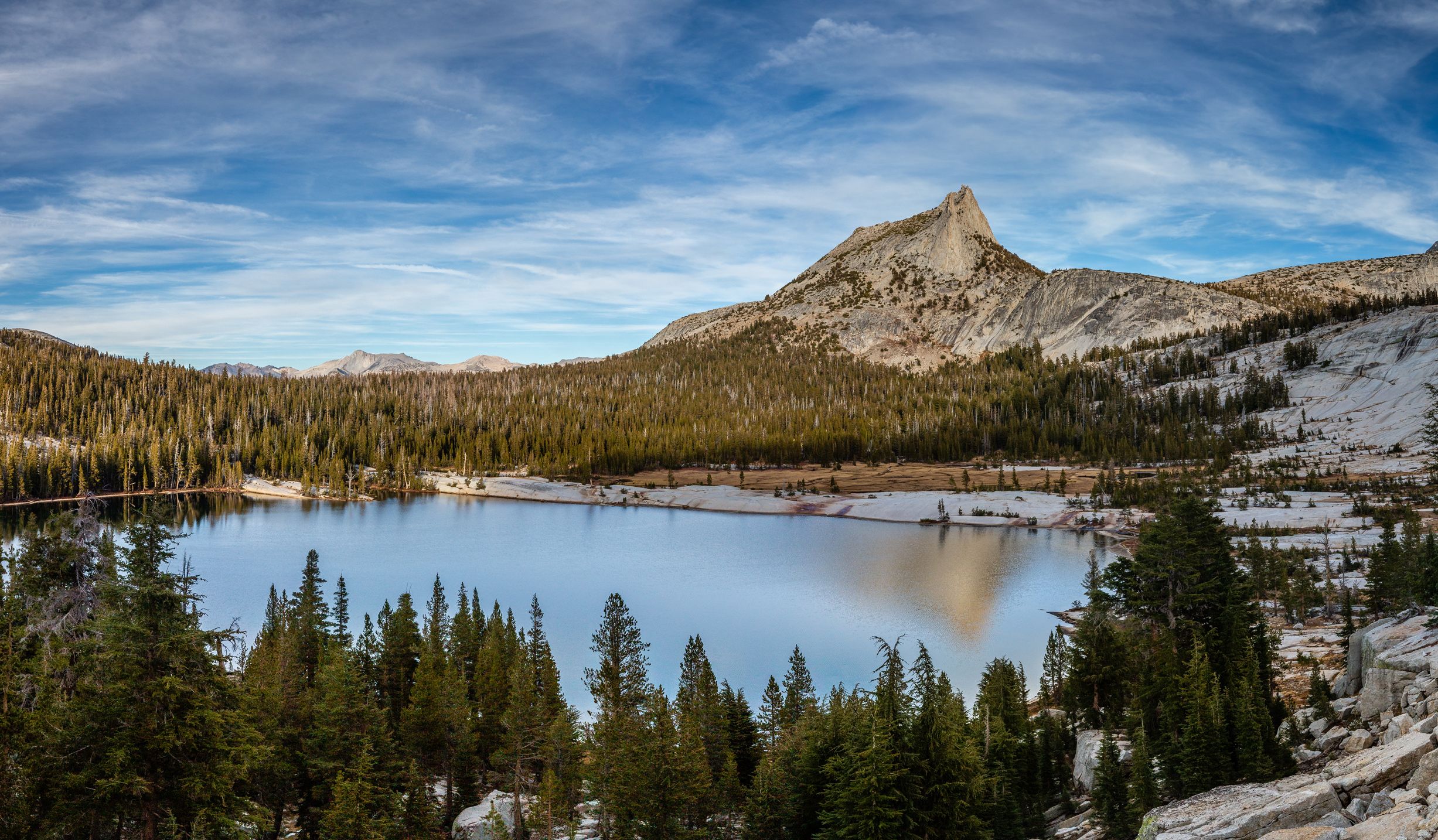
From the pinnacle of the trail, at about three miles in, the trail descends over its last .5 miles stretch into the Cathedral Lake basin. The basin consists of a high shelf of land, ringed with high granite walls and ornamented on its east side by the jagged form of Cathedral Peak. On the east side of the basin is a grassy meadow and on the west the clear cold waters of Cathedral Lake.
Ben Blankenship
As we entered the bowl-like basin, the light was just lowering to be soft warm enough to make for perfect photographic conditions. And, the clouds had decided to play that day, providing some very welcome texture to the autumn sky. The vantage points around the lake are innumerable. So, after a quick rest and a snack, we all sauntered off in our own directions around the lake. I chose to climb the sloping granite walls to the south of the lake in an effort to gain an aerial view of the lake and basin. The climb is not too treacherous, with rock ramps slanting up the wall that made ascending straightforward and easy enough. I found a few perches I liked and shot a series of panoramas and a few stacked images to capture the full majesty of the lake and Cathedral Peak just beyond.
After about an hour and a half shooting at the lake, we packed our bags and began the 3.5-mile walk back to the vehicle. We were able to make it just over halfway down before needing to don headlamps in the quickly receding light. Hiking in the night is a real pleasure for me, and though perhaps less enjoyable for some, it provides an opportunity to experience the forest with the moon and stars.
The following day was to be our last full day in the park, and we had planned a very special hike to commemorate the trip. For our final hike, we would be hiking first to Taft Point to peer over a 1000 foot cliff, and then climbing to the top of Sentinel Dome for a 360-degree view of the valley and an aerial view of nearly everywhere we had been on the trip.
From our trailhead along Glacier Point Road, we hiked the 1.5 miles to Taft Point. Named for America’s 27th president, William H. Taft, Taft Point is best known for its giant fissures that open up to 1000 foot drops to the valley floor below. In fact, it was from Taft Point that a couple of Instagram daredevils fell last year and lost their lives as a result. However, if approached with caution and deference, the views offered from Taft Point are awe inspiring as well as hair raising.
From Taft Point, we caught the Sentinel Dome Loop trail, which skirts along the high wall at the south side of the valley. There are several epic view points along the trail of the valley floor far below. From Taft Point to the top of Sentinel Dome is about 3 miles and an elevation gain of around 1000 feet.
The trail is mostly flat, or even downhill, until the last mile, which takes you up to the top of the dome. Sentinel Dome is a completely bald granite dome with a peak at over 8,000 feet. And from here, hikers are rewarded with a 360-degree view of the park and all of its famous peaks, including El Capitan, Cathedral Rock, Royal Arches, Yosemite Falls (though sometimes dry in fall), Half Dome, and far in the distance, the high peaks of the park’s northeast corner. For our BCJ group, it is like one glorious recap of everywhere we had been throughout the week. Far below us, we could see the Merced River meandering through the valley, cruising amongst the bases of the giant granite features where we had spent every morning of the last week.
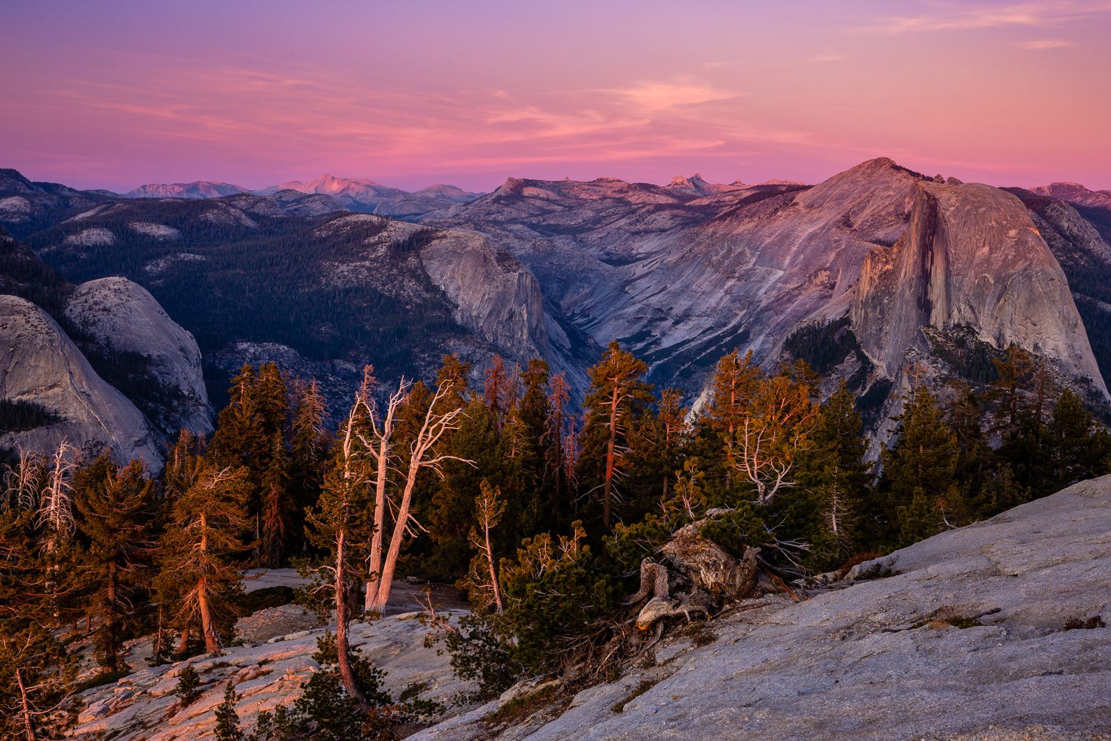
And, Sentinel Dome is one of the best places to see a sunset. With a vantage point high above the surrounding walls, the last light of day beams into the valley creating dramatic sunbeams that kiss off El Capitan and Half Dome. And, as the beams fade, and the granite goes dark, the sky lights up with an unforgettable display of reds, pinks, and yellows, fading into the deep purple of the eastward horizon. It is truly one of my favorite places on Earth, and it is always such a joy to share with our clients. It is a beautiful reward after the effort of the climb and a week of early mornings to chase the magic autumnal light in a landscape like no other.
We would spend the entirety of the sunset there atop the dome, photographing all angles, and then eventually settling and sitting just to enjoy nature’s beautiful handiwork. Just before night, we donned headlamps and began the one-mile trek to complete the Sentinel Dome Loop back where we had begun our walk, thus completing an epic last full day of a beautiful two trips spent in the park.
The following morning was to be our last in the park, and by that afternoon we would be back in Fresno saying goodbyes. But, as we did with our standard group, our final stop would be the Mariposa Grove of giant sequoias.
It is interesting for many people to learn that it was not the boundless beauty of Yosemite Valley that initially inspired the preservation of what would later become Yosemite National Park by Abraham Lincoln in 1864; it was the Mariposa Grove. But, the Yosemite Grant was a landmark move by our government and thus created the first federally protected wilderness in the world. And though Yellowstone was the first to be named a national park, it was Yosemite and those dedicated to its preservation that paved the road for that to happen.
And, their inspiration for what has been called the best idea America ever had, the Mariposa Grove, is truly a land of giants. Access to the grove is via a short hike from the parking area. The trail gently climbs for less than a mile until reaching the oldest tree in the grove, the Grizzly Giant. The Grizzly Giant is truly a behemoth, and its size and impact are impossible to fully comprehend until standing next to it. With a height of over 200 feet and girth of over 100 feet, the tree is older than Jesus, with an estimated age of around 2,200 years old.
After seeing this tree for the first time, most people quickly come to understand how Mariposa Grove inspired the protection of the Yosemite area. I mean, how could one not be inspired to preserve an organism over two millennia old?
This would mark the end of my two weeks in Yosemite National Park this fall. And, it had been two weeks spent with two amazing groups of people. As a guide and instructor, it is my job to educate and navigate. But, I’ve yet to run a trip where I didn’t learn a great deal from my clients. And these trips exhibited this relationship even more so than usual. I walked away from it with a great sense of connection to the park, nature, and those with whom I had shared it. Yosemite is a magical place that I look froward to continuing to explore and photograph over the years to come and share with people whose love and admiration for the park match my own.

We offer world-class travel photography
experiences around the world.
Each tour is bundled with lodging, meals, and transportation between workshops included, allowing you to focus on photography instead of the stress of traveling.
experiences around the world.
Each tour is bundled with lodging, meals, and transportation between workshops included, allowing you to focus on photography instead of the stress of traveling.
Get Our Trip Catalog
Receive a trip catalog that highlights all of our upcoming photo tours and workshops.Schedule a Trip Consultation
Meet with a photo experience coordinator, and experience a personal touch to your booking experience.Trip Calendar
View our trip calendar and filter upcoming departures by interest or seasonality.Webinars
Our regularly hosted webinars provide photography instruction from our own guides on a wide range of topics.Education Portal
Explore our library of articles that cover everything from common questions, to in-depth guides on how to achieve that perfect shot.BACKCOUNTRY JOURNEYS
"Backcountry Journeys offers guests the unique opportunity to explore our natural world from behind their own lens. We run a selection of hand-crafted Photo Tours, Workshops & Safaris connecting passionate people to exceptional experiences. Locations worldwide.
- Russ Nordstrand, Backcountry Journeys Founder & Director
- Russ Nordstrand, Backcountry Journeys Founder & Director
TRIP CATALOG
Download our Trip Catalog for detailed information on our many destinations for photography tours, workshops, and safaris.
All Images & Content are property of Backcountry Photography Tours, Workshops & Safaris LLCs - Copyright 2025
BACKCOUNTRY JOURNEYS
"Backcountry Journeys offers guests the unique opportunity to explore our natural world from behind their own lens. We run a selection of hand-crafted Photo Tours, Workshops & Safaris connecting passionate people to exceptional experiences. Locations worldwide.
All Images & Content are property of Backcountry Journeys Photography Tours, Workshops & Safaris LLC - Copyright 2025
TRIP CATALOG
Download our Trip Catalog for detailed information on our many destinations for photography tours, workshops, and safaris.